


JurnalPost.com - Prolonged heat, drought, extreme rainfall, and unusual seasonal shifts are often linked to two climate phenomena known as El Niño and La Niña.
These are not merely local weather changes. El Niño and La Niña are part of a large-scale climate system that influences rainfall and temperature patterns across the globe, including in Indonesia.
Scientifically, these phenomena are part of the El Niño–Southern Oscillation (ENSO), which involves periodic changes in sea surface temperatures and atmospheric conditions in the tropical Pacific Ocean, particularly in its central and eastern regions.
ENSO has two opposing primary phases: El Niño and La Niña. Between them lies a neutral phase, where ocean and atmospheric conditions remain relatively close to normal.
So, what exactly are the differences between El Niño and La Niña, and how significantly do they impact human life?
What Is El Niño?
El Niño is a condition where sea surface temperatures in the central to eastern tropical Pacific become warmer than normal.
Under normal conditions, trade winds blow from east to west across the tropical Pacific. These winds help push warm water masses toward the western Pacific, including the Indonesian region.
When El Niño occurs, these trade winds typically weaken. As a result, the warm water that usually accumulates in the western Pacific shifts or expands toward the central and eastern Pacific Ocean.
This change in sea temperature subsequently affects the atmospheric circulation above it.
The regions of cloud and rain formation that are usually active around Indonesia and the western Pacific can shift further toward the central or eastern Pacific.
For Indonesia, this condition generally leads to a reduction in rain cloud formation in several areas.
The impacts can include decreased rainfall, a drier dry season, increased drought risk, reduced water availability, and a higher potential for forest and land fires.
However, the impact of El Niño is not identical in every region or every event. The intensity of the El Niño, the season in which it occurs, and regional atmospheric conditions all determine the scale of the impact.
Why Does El Niño Make Indonesia Drier?
Indonesia is located in the western Pacific, a region with relatively warm sea temperatures that serves as a hub for tropical rain cloud formation.
When El Niño develops, the center of warm water and convection activity—or cloud formation—can shift toward the central and eastern Pacific.
Consequently, the supply of water vapor and rainfall activity in parts of Indonesia can decline.
This explains why El Niño is often associated with a drier dry season compared to normal conditions.
While Indonesia and Australia may experience reduced rainfall, some regions in the eastern Pacific may actually receive more rain than usual.
This is one of the primary characteristics of ENSO: changes occurring in one part of the Pacific Ocean can influence the atmosphere thousands of kilometers away.
What Is La Niña?
If El Niño is marked by the warming of sea surface temperatures in the central and eastern Pacific, La Niña is the opposite condition.
During La Niña, sea surface temperatures in the central and eastern tropical Pacific become colder than normal.
The trade winds blowing from east to west generally become stronger. This condition pushes more warm water toward the western Pacific region.
As a result, the waters around Indonesia can become relatively warmer, providing more water vapor for cloud formation.
Therefore, La Niña is often associated with increased rainfall across most of Indonesia.
If it is strong or coincides with other weather factors, this increased rainfall can heighten the risk of floods, landslides, waterlogging, and disruptions to the agricultural and transportation sectors.
Once again, La Niña does not mean that all of Indonesia will experience constant heavy rain.
Its influence can vary between regions because Indonesia's weather is also affected by monsoons, local sea temperatures, topography, tropical cloud movement, and various other atmospheric factors.
El Niño and La Niña Are More Than Just Opposites
At a glance, El Niño and La Niña appear to be two phenomena that differ only in terms of heat and cold.
However, their influence is far more complex.
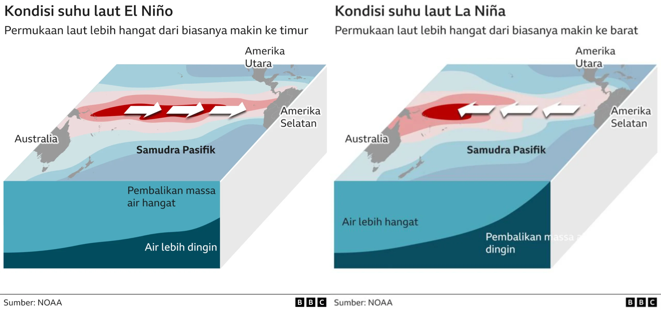
Changes in sea temperature in the Pacific Ocean can alter global atmospheric circulation patterns. Consequently, the affected areas are not limited to countries bordering the Pacific Ocean.
El Niño may be linked to drought in one region while increasing the likelihood of rain in another.
The same applies to La Niña. While Indonesia may receive additional rainfall, other regions may experience conditions that are drier or colder than normal.
Because the Earth's atmosphere is interconnected, major changes in the Pacific Ocean can affect weather patterns as far away as the Americas, Africa, Asia, and Australia.
Impacts on Agriculture and Food Security
One of the sectors most sensitive to ENSO is agriculture.
During El Niño, reduced rainfall can lead to a decline in irrigation water supplies. Crops that require large amounts of water are potentially at risk of drought stress.
If the planting season is not adjusted to climate conditions, the risk of reduced production can increase.
Conversely, excessive rain during La Niña can also be problematic.
Waterlogged fields can suffer from flooding, harvest processes can be disrupted, and high humidity can potentially support the development of certain plant pests and diseases.
Therefore, information regarding ENSO developments is crucial for determining planting calendars, water management, variety selection, and mitigating the risk of crop failure.
Impacts on Fires and Hydrometeorological Disasters
El Niño also frequently receives attention because it is linked to an increased risk of drought and forest or land fires.
When rainfall decreases over a long period, vegetation and land become drier, making them more susceptible to fire.
Meanwhile, when La Niña increases rainfall, the risk of disaster can shift to floods, flash floods, and landslides, especially in areas with poor drainage systems or vulnerable slopes.
Thus, both El Niño and La Niña require preparedness.
Not because they always result in disaster, but because changing climate conditions can increase vulnerability if not anticipated.
Is ENSO the Same as Climate Change?
El Niño and La Niña are different from climate change.
ENSO is a natural phenomenon that has occurred repeatedly within the Earth's climate system. Its cycles can last over several years, and its intensity varies from one event to the next.
Meanwhile, climate change relates to long-term shifts in the Earth's climate system, including an increase in global average temperatures due to rising greenhouse gas concentrations.
Although different, they can interact with each other.
In an increasingly warming world, the impact of an El Niño or La Niña event can occur amidst a baseline climate that has also changed. Therefore, scientists continue to study how global warming affects the character and long-term impacts of ENSO.
Why Should the Public Understand El Niño and La Niña?
Understanding ENSO is not only important for meteorologists or climate researchers.
Information about El Niño and La Niña can be used by farmers to plan planting seasons, by the government to anticipate droughts and floods, by water resource managers to maintain supplies, and by the public to improve preparedness for extreme weather.
It is also important to understand that El Niño and La Niña are not the sole determinants of Indonesia's weather conditions.
These phenomena provide a tendency for climate conditions over a certain period, while daily weather remains influenced by many other factors.
Therefore, ENSO information should be read in conjunction with official weather and climate forecasts so that the public can obtain a more complete picture.
Conclusion
El Niño and La Niña are two primary phases of the ENSO phenomenon, which stems from the interaction between the ocean and the atmosphere in the tropical Pacific Ocean.
El Niño is marked by warming sea surface temperatures in the central and eastern Pacific and generally increases the chance of drier conditions in Indonesia. Conversely, La Niña is marked by the cooling of that region and often increases the chance of rainfall in Indonesia.
The impacts can reach various sectors, ranging from agriculture, water resources, and environmental health to forest fires and the risk of hydrometeorological disasters.
Therefore, understanding El Niño and La Niña is not just about studying weather phenomena. This understanding is a vital part of society's efforts to adapt to climate dynamics.
Because changes in sea temperature occurring thousands of kilometers away can lead to questions very close to daily life: when will the rain come, how long will the dry season last, and how prepared are we to face these changes?






Comments 0
Write a Comment Share your response